These maps are used in my novel Son of Mary (Book 1 in the Crown of Thorns series). I created these maps myself in a special map-drawing program, Ortelius. These maps are copyright Randall Ingermanson, 2020. I have provided them solely for your own personal use. You may not rent, sell, or give them away. You may not include them in your own website, book, or any other published material.
If you like these maps, consider following me via e-mail. I expect to add new maps to this page as I write more novels, and when I do, I’ll notify my Loyal Readers first via my e-mail newsletter.
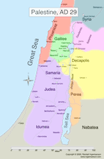
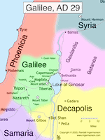
The regions of Judea, Samaria, and Idumea were ruled over by a Roman governor, Pontius Pilate. Galilee and Perea, although not connected to each other, were ruled over by a Jewish tetrarach, Herod Antipas, son of Herod the Great. Antipas was sometimes called a “king” but he was only a tetrarch. His brother Herod Philip ruled over the regions of Gaulanitis and Batanea. Philip was also a tetrarch. The region of the Decapolis (“ten cities”) was a mostly gentile region.
Galilee was a small region ruled by Herod Antipas, a Jewish tetrarch who was a son of Herod the Great. The region was only about 30 miles across, which means you could walk from any part of Galilee to any other in less than two days. Galilee had a population of probably no more than 100,000 people, mostly Jewish. When Antipas began ruling over it in 4 BC, the capital city was Tsipori, only about 3 miles from Nazareth. Sometime in the early 20s, Antipas moved his capital to a newly created city, Tiberias, named after the emperor, Tiberius Caesar. In modern Israel, Tsipori is now an archaeological park. Tiberias is a thriving city, and several extremely famous rabbis are buried there.
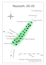
Nazareth in the time of Jesus was a typical Galilean village with a population of about 200. It had probably been settled less than 100 years earlier. Modern Nazareth is a densely populated city. The first-century village runs roughly along the current “Paulus ha-Shishi St.” (Paul the 6th St.). The modern-day Basilica of the Annunciation sits about where the southern-most house in the map is marked. Very little has been excavated from the first century, mostly in the area south of the village square in the map. The modern-day “Mary’s Well” is located precisely where the village spring is shown on the map. In the first century, the spring was outside the village and connected to it by a narrow wadi. The map shown is mostly guesswork, but the guesses are based in reality.
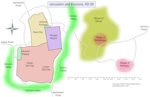
The map shown is the result of combining two maps from Son of Mary. (Pages in a book are taller than they are wide, so it just wasn’t possible to show the map in one connected piece in the book.) Jerusalem in AD 29 was a small city of maybe 1/3 of a square mile, with a population of about 30,000. The city was surrounded on three sides by steep valleys–to the east, south, and west, making for strong defenses. The northern side was not so easy to defend. The Temple Mount covered an enormous area. The Mount of Olives stood directly west of the city, with two small villages, Bethphage and Bethany. The roads have been drawn to follow the contour lines–the region is quite hilly, and roads naturally take the path of least resistance.
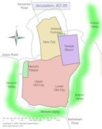
This is one of a pair of maps from the book Son of Mary. This one shows Jerusalem in the early part of the first century. Probably in the early 40s, the northern wall was extended to enclose more territory by King Herod Agrippa I, and that wall closely follows the current wall of the Old City of Jerusalem in modern Israel. The modern-day Church of the Holy Sepulchre, which is inside the current Old City, was just west of the area marked New City on the map. This is the traditional site of the crucifixion of Jesus, and many scholars believe that it may be very close to the actual site. But a fair number of scholars disagree.
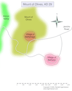
This is the second of a pair of maps from Son of Mary. This shows the Mount of Olives and two villages that lay on it, Bethphage and Bethany. Bethany is the home village of three friends of Jesus–Mary, Martha, and Lazarus. The traditional site of the tomb of Lazarus is not marked on the map, but it is just to the southeast of the village marked on the map. The two villages had populations of about 200 to 300. The roads are guesses, based on the contour lines from a topographical map. They’re laid out to minimize the ups and downs in the road, since people naturally take the laziest route when they have a choice.