I live in a small town. The population is about 20,000. I don’t feel terribly isolated, because we’re half an hour from a much larger town of about 200,000. And we’re right across the river from a good sized city of over 600,000.
It’s worth noting that my small town is about twice the size of the largest cities in Galilee at the time of Jesus. At the time he began preaching the news of the kingdom of God, the capital of Galilee was Tiberias, with a population of about 10,000. Tiberias was a day’s walk from Nazareth, so Jesus probably didn’t get there very often.
The other large city in Galilee was Tsipori, which also had a population of about 10,000. This city had been the capital of Galilee when Jesus was a boy, but the ruler of Galilee (Herod Antipas) moved his capital to Tiberias at some point when Jesus was in his twenties.
Tsipori was only about an hour’s walk away from Nazareth, so it would have been easy for Jesus to visit. It’s a good bet that he went there often, because Nazareth was quite small. Archaeologists have estimated the size in acres of the village of Nazareth to be 5 to 10 acres, with a population absolutely no more than 400, and probably a lot less.
What Nazareth Was Like
My best guess is that Nazareth had a population of around 200 people. That may seem tiny, but in the time of Jesus, it was a respectable size. In my blog post Around Galilee With Jesus, I estimated the sizes of the villages and towns in Galilee to range from around 10,000 down to about 100. A village of 200 souls would have been slightly above the 50th percentile, meaning 50% of villages were smaller. So Nazareth was a typical-sized village.
Jesus and his father and his four brothers probably all worked in the same trade, which was a problem. If there were 50 adult men in the village, then the six men in his family would have been 12% of the entire adult male population.
It seems implausible that there would have been enough work in Nazareth for all of them. Their trade is named in Mark 6:3 using the Greek word “tekton.” This is usually mistranslated “carpenter,” but the Biblical scholars say that a tekton could be any worker in wood, metal, or stone. In essence, they were builders. A sleepy village like Nazareth would probably not have enough work for them all, but the large town of Tsipori had a lot going on. So that explains why I think Jesus and his family went there often.
Nazareth today is a densely packed town in Galilee with a population of more than 75,000. The first-century village was built alongside the broad avenue now called Paulus ha-Shishi (named after Pope Paul the 6th). The modern Basilica of the Annunciation sits at the southern end of the first-century village, and the modern Mary’s Well is located a few hundred yards north of the northern end of the first-century village.
Reconstructing Nazareth
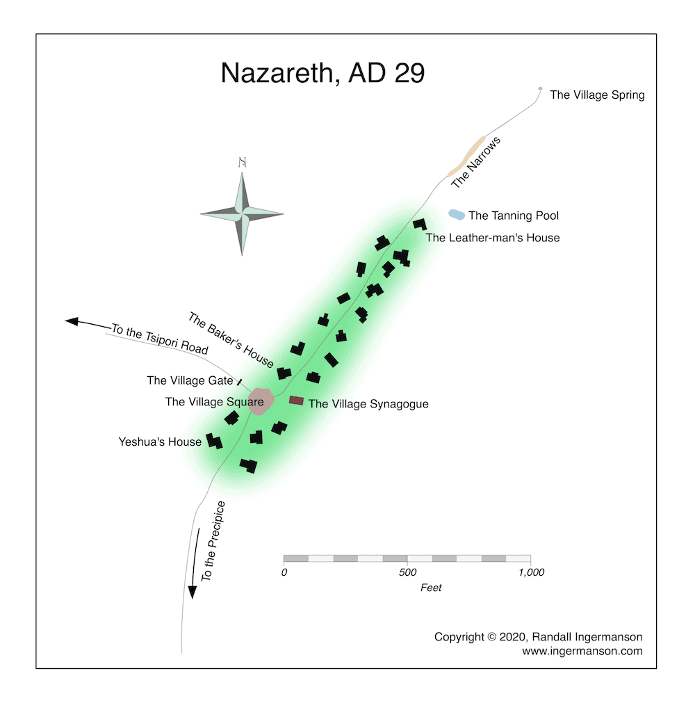
Only a very few first-century houses have been excavated (near the southern end). So we don’t have a very good idea of how things were laid out. All we can say is that the village was shaped somewhat like a zucchini, with the fat end in the south and the thin end in the north.
There’s a tourist site called Nazareth Village that I found helpful in visualizing the first-century village. It’s not perfect, but it was built in consultation with some real archaeologists. The guides dress up in first-century garb, and you can see a carpenter’s shop, a weaver’s shop, a synagogue, a threshing area, a pen with some livestock, all manned with humans dressed approximately like first-century villagers. You can also eat a first-century lunch. It’s definitely worth a visit, and the more you know about history and archaeology, the more you’ll appreciate the place.
When I was working on my most recent novel, Son of Mary, I created a map of first-century Nazareth based on everything I know—some books I’ve got, plus several visits I’ve made to Nazareth, which included two stops at Nazareth Village.
Nazareth is built on a hill. If you walk a bit more than a mile south from the first-century village, you’ll come to a place now called Mount Precipice. This is a fairly steep slope going down into the Jezreel Valley. It’s the traditional site of the story told in Luke 4:16-30, in which Jesus is nearly thrown off the “precipice” by his own hometown. I’ve visited this site several times, and it seems to me a very plausible place to stage a traditional execution by stoning. (The traditional method is to push somebody into a pit or over a drop of about 10 feet. If that doesn’t break their neck, then you drop large rocks on them until they die. Everything needed for this kind of stoning was available right there at Mount Precipice.)
A Map of Nazareth
It’s not possible to make an accurate map of the first-century village of Nazareth, because we just don’t know enough. But it’s possible to imagine the village and create something that is at least consistent with the information we have.
And that’s what I did for my book. Here is the map I ended up drawing, based on the 10% we actually know and using my imagination for the 90% that we don’t know.

